Polynomial Rectification
Rectification is the process of projecting the data onto a plane and
making it conform to a map projection system.
Assigning map
coordinates to the image data is called georeferencing.
Rectify a Landsat
Image : Image to Image
Rectification
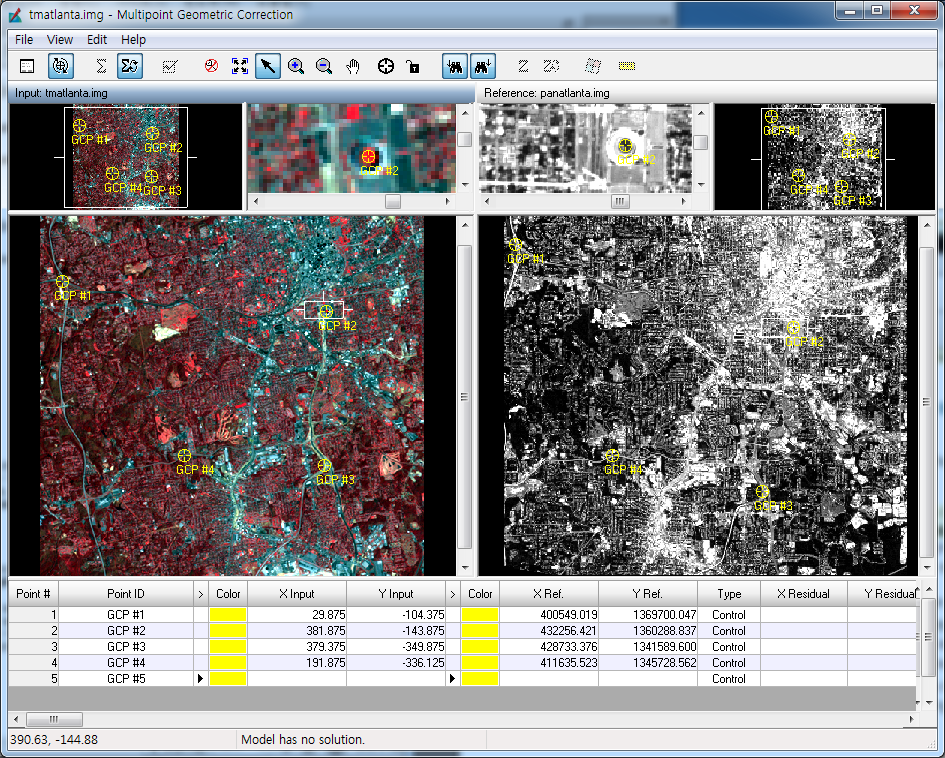
You rectify a Landsat TM image of Atlanta, Georgia, using a georeferenced SPOT panchromatic image of the same area.
The SPOT image is rectified to the State Plane map projection.
basic steps in rectifying the Landsat image
- display files
- start Geometric Correction Tool
- record GCPs
- compute a transformation matrix
- resample the image
- verify the rectification process
- Display tmAtlanta.img in Gray Scale of Layer 2
- Start GCP tool - Raster : Panchromatic : Transform&Orthocorrect : Control Points
- In the "Select Geometric Model" dialog, select Polynomial and then click
OK.
- Collect Reference Points From : select "Image Layer (New Viewer)" and then click OK
- Select panAtlanta.img and then OK
- Polynomial model Parameters : close
Selecting GCPs
: You
should choose points that are easily identifiable in both images, such as
road intersections and landmarks.
- In order to make GCP #1 easier to see, right-hold in the Color column to the right of GCP #1 in the GCP Tool CellArray and select the color
Yellow.
- click the Create GCP icon and select a GCP in the Input viewer.
- click the Create GCP icon and select a GCP at the corresponding location in the Reference viewer.
- Digitize at least two more GCPs in each Viewer (on tmAtlanta.img in
the first Viewer and panAtlanta.img in the second Viewer) by repeating
the above steps. The GCPs you digitize should be spread out across
the image to form a large triangle (that is, they should not form a line).
Calculate Transformation
Matrix from GCPs
- The Auto Calculation function is enabled by default in the GCP Tool.
The Auto Calculation function computes the transformation in real time
as you edit the GCPs or change the selection in the CellArray.
- Click "Display Model Property" icon and click Transformation tab. : The transformation matrix contains the coefficients for
transforming the reference coordinate system to the input coordinate
system.
- you can move
a GCP in the Viewer while watching the transformation coefficients and
errors change at the top of the GCP Tool.
Digitize Check Points - checking the accuracy of your
transformation.
- In the last row of the CellArray, right-hold in each of the two Color columns and select Magenta.
- Edit => Set Point Type => Check
- Edit => Point Matching
- Correlation Threshold to .8 , and then press the Enter key on your
keyboard.
- Click the Discard Unmatched Point checkbox to activate it.
- In the GCP Tool, click the Create GCP icon and then the Lock icon. Create five check points in each of the two Viewers, just as you did for
the GCPs.
Resample the Image
- Click the Resample icon in the Geo Correction Tools.
- under Output File, enter the name
tmAtlanta_georef.img
- Under Resample Method, click the dropdown list and select Bilinear
Interpolation.
- Click Ignore Zero in Stats
- Click OK
Verify the Rectification Process
- Display the resampled image (tmAtlanta_georef.img) in the first
Viewer.
- Display the reference image (panAtlanta.img) in the second
Viewer.
or
- Display both the resampled image (tmAtlanta_georef.img) and the reference image (panAtlanta.img) in the same
Viewer
- Start Swipe in the quick menus
% In class assignment, do the same procedure as above with polynomial orer of 2 .